

| Picture Credit: “Old Harrys Rocks” by Beth M527 is licensed under CC BY-NC 2.0 |
It started tens of millions of years ago
The Isle of Purbeck is a peninsula in Dorset. It is not an island in geographical terms: It covers a 60-square mile area jutting into the English Channel, bordered on three sides by sea and on the remaining side, the North, partly by the River Frome, thus giving it a peninsula character. It is dominated by the Jurassic Coastline, the chalk ridge known as the Purbeck Hills and bordered by Poole Harbour, one of the largest natural harbours in the world.
The area’s geography has given Purbeck an abundance of riches to quarry since ancient man arrived on its shores. As well as its fertile soil, it has navigable rivers, ports, and high defensive hills as protection from enemies.
Today, Purbeck is best known for some of the most beautiful and iconic scenery in the South of England.
The chalk headlands started their formation tens of millions of years ago and are still not done. Thousands of years ago, these stacks would have been connected, but time and tide have taken their toll over the ages. Many rock formations like these have come and gone in the meantime, and new ones are still forming as the sea finds weaknesses in the stone, forming arches that eventually collapse, creating new stacks.
Sitting at the eastern end of the 95-mile long Jurassic Coast World Heritage Site, the Pinnacles’ story begins in the later Cretaceous period, when the skeletons of sub-microscopic plankton drifted to the bottom of what was then a tropical sea. Fast forward millions of years, and this process formed the white limestone known as chalk – the fossilised remains of billions of tiny sea creatures, frozen forever on England’s south coast. In terms of natural landscape areas, the southern part of the Isle of Purbeck and the coastal strip as far as Ringstead Bay in the west is designated as National Character Area 136 – South Purbeck by Natural England. To the North are the Dorset Heaths, and to the west are the Weymouth Lowlands.
Marble and Limestone
Purbeck stone has been used as a traditional building and paving material since at least Roman times and has been a key element in the building of many of Britain’s Cathedrals as a decorative building stone.
Purbeck Marble is a fossiliferous limestone[1]. Stratigraphically[2], these limestone beds lie towards the top of the Durlston Formation of the Purbeck Group. They were deposited during the Berriasian age of the Early Cretaceous epoch. Purbeck Marble is not a metamorphic rock, like a true marble, but is so-called because it can take a fine polish.
In the past, limestone quarrying was undertaken – mainly concentrated around the western side of Swanage, the villages of Worth Matravers and Langton Matravers, and the cliffs along the coast between Swanage and St. Aldhelm’s Head.
The “caves” at Tilly Whim are former quarries, and Dancing Ledge, Seacombe and Winspit are other cliff-edge quarries. Stone was removed from the cliff quarries either by sea or by using horse carts to transport large blocks to Swanage. Many of England’s most famous Cathedrals are adorned with Purbeck marble, and much of London was rebuilt in Portland and Purbeck stone after the Great Fire of London in 1666.
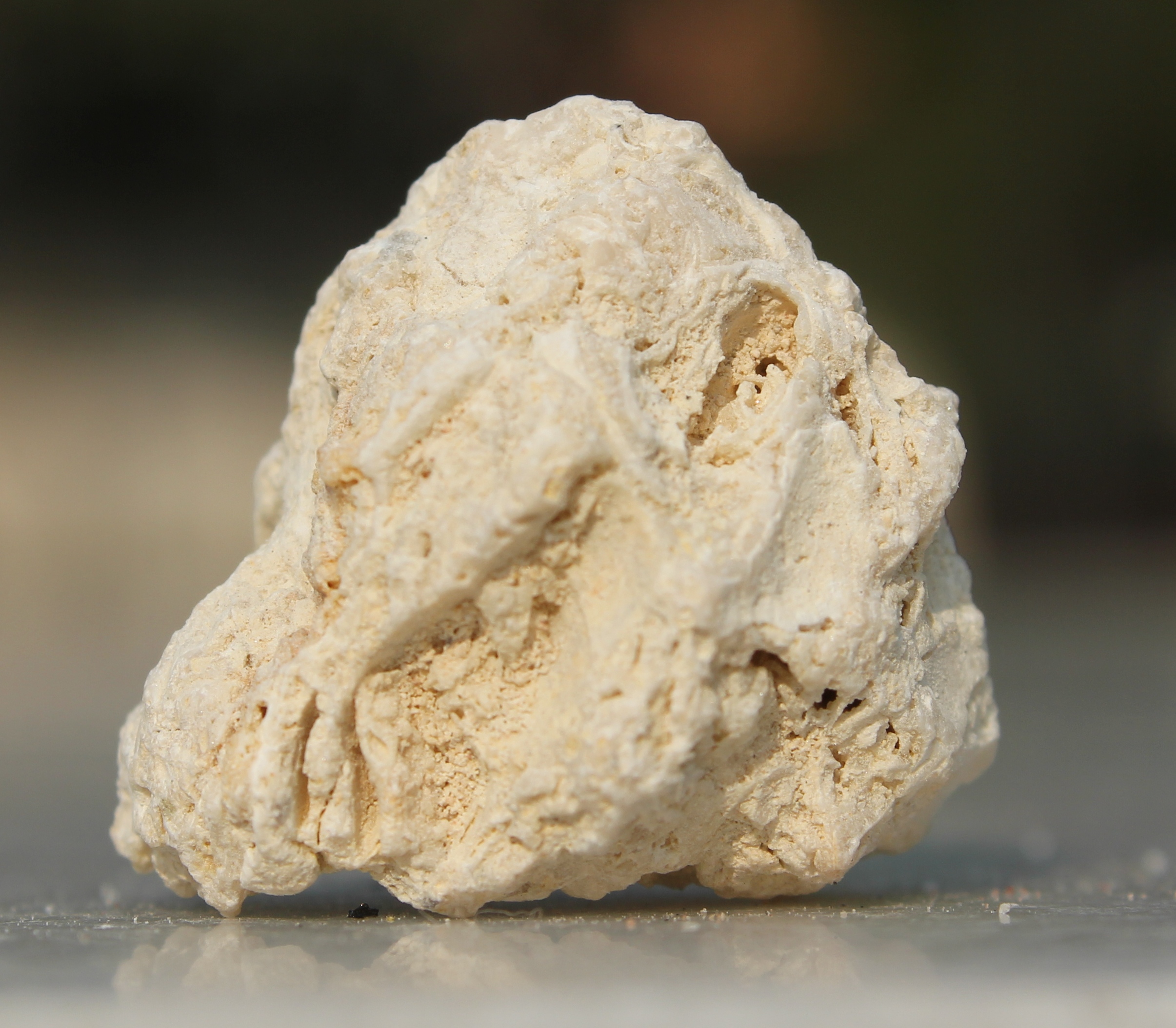
Fossiliferous Limestone

Picture Credit: This file is licensed under the Creative Commons Attribution-Share Alike 3.0 Unported license.
Attribution: Manishwiki15, CC BY-SA 3.0 <https://creativecommons.org/licenses/by-sa/3.0>, via Wikimedia Commons
File URL: https://upload.wikimedia.org/wikipedia/commons/e/ed/Fossiliferous_Limestone.JPG
Clay
By contrast to Purbeck stone, the principal ball clay[3] workings were in the area between Corfe Castle and Wareham.
Originally, the clay was taken by packhorse to wharves on the River Frome and the south side of Poole Harbour. However, in the first half of the 19th century, the pack horses were replaced by horse-drawn tramways. In the mid-1800s, with the arrival of the railway from Wareham to Swanage, most ball clay was dispatched by rail, often to the Potteries district of Staffordshire.
Quarrying still takes place on Purbeck, with both Purbeck Ball Clay and limestones being transported from the area by road. There are now no functioning quarries of Purbeck Marble. The Purbeck Mineral and Mining Museum has an exhibition about ball clays, mining and the associated narrow gauge railways.
The ceramic use of ball clays in Britain dates back to the Roman era or even earlier. More recent trade began when clay was needed to make tobacco pipes in the 16th and 17th centuries. In 1771, Josiah Wedgwood signed a contract for 1400 tons a year of ball clay with Thomas Hyde of Purbeck, enabling Wedgewood to fire thinner-walled ceramics[4].
Geology
The isle has the highest number of species of native and anciently introduced wildflowers of any area of comparable size in Britain. The most frequently sought species is Early Spider Orchid (Ophrys sphegodes), and it is most common on Purbeck.
Late April is the best time to visit, and the largest population is usually in the field to the west of Dancing Ledge. Smaller numbers can be seen on a shorter walk in Durlston Country Park.
An Area of Outstanding Natural Beauty but The Ministry of Defence is ever-present
A large part of the district is now designated as an Area of Outstanding Natural Beauty (AONB). However, a portion of the coast around Worbarrow Bay and the ghost village of Tyneham is still, after many years, controlled by the Ministry of Defence, who use it as a training area:
- Lulworth Ranges are part of the Armoured Fighting Vehicles Gunnery School at Lulworth Camp.
- Tanks and other armoured vehicles are used in this area, and shells are fired.
- For safety reasons, the right of entry is only given when the army ranges are not in operation.
- Large red flags are flown and flashing warning lamps on Bindon Hill and St Alban’s Head are lit when the ranges are in use. At such times, the entrance gates are locked, and wardens patrol the area.
Other Spots
- Swanage, at the eastern end of the peninsula, is a seaside resort. At one time, it was linked by a branch railway line from Wareham. It was closed in 1972 but has now partially reopened as the Swanage Railway, a heritage railway.
- Studland is a seaside village with its own sandy bay.
- Nearby, lying off-shore from The Foreland (also Handfast Point), are the chalk stacks named Old Harry Rocks: Old Harry and his Wife.
- Poole Harbour is popular with bird watchers, windsurfers and yachters; it contains Brownsea Island, the site of the first-ever Boy Scout camp.
- Corfe Castle is in the centre of the isle, and it overlooks Corfe Castle village.
- Langton Matravers was once the home of several boys’ preparatory schools; the last of these, The Old Malthouse School, closed in 2007.
- With its fossil-rich Jurassic shale cliffs, Kimmeridge Bay is the site of the oldest continually working oil well in the world.
- Worth Matravers is a village of stone houses around a pond, regularly featured on postcards of the Isle of Purbeck.
Earlier Occupants of the Area
There are several Iron Age, Roman, and Saxon archaeological sites on the Isle of Purbeck. Nine Barrow Down, for example, takes its name from the nine barrows (stone age burial mounds) that have been found along this ridge on the northern side of the Purbeck Hills, while Flowers Barrow, near Kimmeridge in the south, is an Iron Age hill fort built 2500 years ago, a part of which has been lost to the sea thereby dramatically demonstrating the effect of coastal erosion. The town of Wareham retains its Saxon earth embankment wall, and its churches have Saxon origins. One of these, St Martins-on-the-Walls, was built in 1030 and today contains traces of medieval and later wall paintings.
Several Romano-British sites have been discovered and studied on the Isle of Purbeck, including a villa at Bucknowle Farm near Corfe Castle, excavated between 1976 and 1991. The Kimmeridge shale of the isle was worked extensively during the Roman period to make jewellery, decorative panels and furniture.
At the extreme southern tip of Purbeck is St Aldhelm’s Chapel, which is Norman work but built on a Pre-Conquest Christian site marked with a circular earthwork and some graves. In 2000 the whole chapel site was declared a Scheduled Ancient Monument.
At Corfe Castle village is the great castle which gives the village its modern name. The castle commands the strategic gap in the Purbeck Ridge and dates from after the Norman Conquest of 1066, but this may replace Saxon work as the village was where Saxon King Edward the Martyr was murdered in 978.
During the English Civil War, the castle was twice besieged by Parliamentarian forces. The first siege, in 1643, was unsuccessful, but by 1645, Corfe was one of the last remaining royalist strongholds in Southern England and fell to a siege ending in an assault. Now owned by the National Trust, the castle is open to the public. It is protected as a Grade I listed building and a Scheduled Ancient Monument.
Sources/Excerpts and Further Reading
- https://en.wikipedia.org/wiki/Isle_of_Purbeck
- https://visitwareham.com/purbeck-and-the-jurassic-coast/
- https://www.dorsets.co.uk/purbeck
- https://dorsettravelguide.com/isle-of-purbeck-travel-guide/https://www.visit-dorset.com/explore/areas-to-visit/purbeck/
- https://dorsettravelguide.com/isle-of-purbeck-travel-guide/
- https://www.britannica.com/science/kaolinite
- https://www.britannica.com/place/Purbeck-Beds
 Picture Credit: “Old Harry Rocks, Isle of Purbeck” by Beth M527 is licensed under CC BY-NC 2.0
-
Fossiliferous limestone (see picture on the next page) is any type of limestone, made mostly of calcium carbonate in the form of the minerals calcite or aragonite, that contains an abundance of fossils or fossil traces. The sort of macroscopic fossils often include crinoid stems, brachiopods, gastropods, and other hard shelled mollusk remains from millions of years ago. Fossiliferous limestone is termed biosparite limestone under the Folk classification of sedimentary rocks (see: https://en.wikipedia.org/wiki/Folk_classification) ↑
-
Stratigraphy is a branch of geology concerned with the study of rock layers (strata) and layering (stratification). It is primarily used in the study of sedimentary and layered volcanic rocks. Stratigraphy has two related subfields: lithostratigraphy (lithologic stratigraphy) and biostratigraphy (biologic stratigraphy). ↑
-
Ball clays are kaolinitic sedimentary clays that commonly consist of 20–80% kaolinite, 10–25% mica, 6–65% quartz. Localised seams in the same deposit have variations in composition, including the quantity of the major minerals, accessory minerals and carbonaceous materials such as lignite. They are fine-grained and plastic in nature, and, unlike most earthenware clays, produce a fine quality white-coloured pottery body when fired, which is the key to their popularity with potters. (Source: https://wiki.vizblog.net/wiki/Ball_clay) ↑
-
Source: “History of Ball Clay – Swanage Railway”. The Purbeck Mineral & Mining Museum. ↑